


belledonne j3

CASSISFRAMBOISE
User
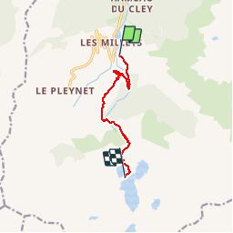

Length
7.6 km

Max alt
2149 m

Uphill gradient
1108 m
Km-Effort
18.8 km

Min alt
1081 m

Downhill gradient
54 m
Boucle
No
Creation date :
2019-09-04 06:47:44.428
Updated on :
2019-09-06 12:14:05.207
4h04
Difficulty : Medium

FREE GPS app for hiking
 SityTrail
IGN / Geographical institutes
SityTrail Plus
The world is yours!
About
Trail Walking of 7.6 km to be discovered at Auvergne-Rhône-Alpes, Isère, Le Haut-Bréda. This trail is proposed by CASSISFRAMBOISE.
Positioning
Country:
France
Region :
Auvergne-Rhône-Alpes
Department/Province :
Isère
Municipality :
Le Haut-Bréda
Location:
La Ferrière
Start:(Dec)
Start:(UTM)
270705 ; 5018378 (32T) N.
Comments